


18503 - HAHIRA UNITED METHODIST Voting District, Lowndes County, Georgia
About
Outline

Summary
| Unique Area Identifier | 562406 |
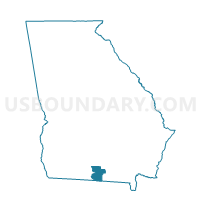
| Name | 18503 - HAHIRA UNITED METHODIST Voting District |
| County | Lowndes County |
| State | Georgia |
| Area (square miles) | 15.65 |
| Land Area (square miles) | 15.17 |
| Water Area (square miles) | 0.47 |
| % of Land Area | 96.98 |
| % of Water Area | 3.02 |
| Latitude of the Internal Point | 30.98529040 |
| Longtitude of the Internal Point | -83.34446980 |
Maps


Graphs
Select a template below for downloading or customizing gragh for 18503 - HAHIRA UNITED METHODIST Voting District, Lowndes County, Georgia


Neighbors
Neighoring Voting District (by Name) Neighboring Voting District on the Map
- 075C - CECIL Voting District, Cook County, GA
- 18502 - NEWSOME ST CHURCH Voting District, Lowndes County, GA
- 18504 - MT OLIVE CHURCH Voting District, Lowndes County, GA
- 18507 - PINE GROVE CHURCH Voting District, Lowndes County, GA
- 18516 - WESTMINSTER PRE Voting District, Lowndes County, GA